Why I Chose the Manaslu Circuit Trek
When I started planning a trek in Nepal, I wanted to experience a part of the Himalayas that felt quieter and less developed than the popular Everest and Annapurna routes. I wanted to walk through small mountain villages, stay in local teahouses, meet people along the trail, and see how life changes as the mountains get higher.
That was what drew me to the Manaslu Circuit Trek.
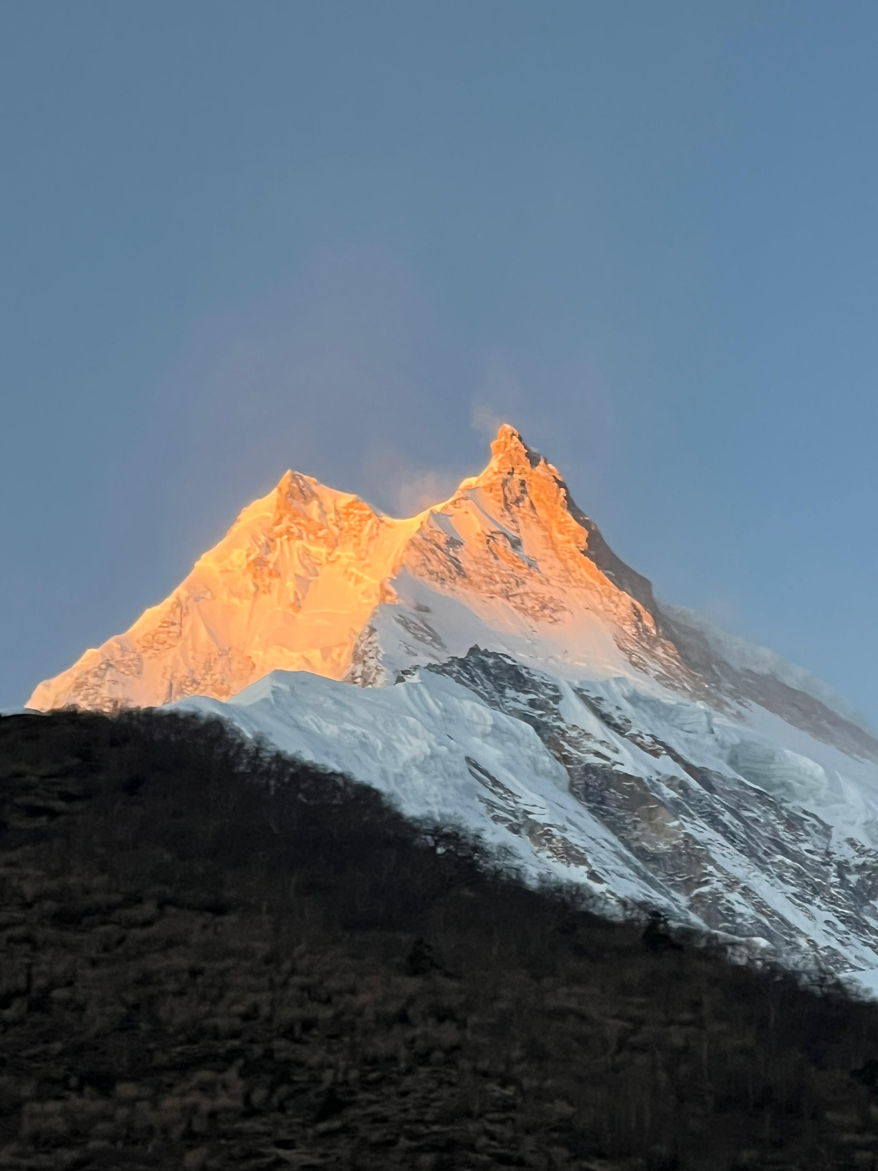
The trek circles Mount Manaslu, the world's eighth-highest mountain, and passes through the remote Budhi Gandaki Valley before reaching the high mountain landscapes around Larkya La Pass. I was particularly interested in the mix of lower river valleys, forested hillsides, stone villages, Buddhist monasteries, and the increasingly barren landscape near the Tibetan border.
What I liked about this route on paper was that it was not only about reaching a high pass. The villages and the journey between them were just as important as the mountains themselves.
Unlike a short hike where the scenery changes little from one day to the next, the Manaslu Circuit involves a gradual transition from warm, green valleys to colder alpine terrain. The higher I imagined travelling, the more the landscape would change.
Manaslu Circuit Trek at a Glance
|
Trekking details
|
Information
|
|
Trekking duration
|
Usually 12–16 days, depending on the itinerary
|
|
Starting point
|
Machha Khola or nearby trailhead, depending on road access
|
|
Ending point
|
Dharapani or another agreed endpoint
|
|
Highest point
|
Larkya La Pass, approximately 5,106 m
|
|
Main mountain
|
Mount Manaslu, 8,163 m
|
|
Accommodation
|
Local teahouses and lodges
|
|
Main difficulty
|
Long walking days, steep trails and high altitude
|
|
Trekking style
|
Mountain villages, remote valleys and high-pass crossing
|
These details are a general overview. The exact distance, daily walking hours, and starting and ending points depend on the chosen itinerary and current road conditions.
Starting the Journey from Kathmandu
The journey begins in Kathmandu, where I would make the final preparations before heading towards the Manaslu region. I would check my trekking equipment, arrange the required permits through a registered trekking agency, and make sure I had enough Nepali cash for the villages along the route.
The drive from Kathmandu towards Machha Khola is not the most comfortable part of the trip. Mountain roads can be rough, dusty and slow, especially after rain or during road construction. I would not expect the journey to feel like a smooth highway drive.
As the road follows the river valleys and passes through settlements, the landscape gradually changes. The busy streets of Kathmandu give way to terraced hillsides, small roadside shops and villages spread along the river.
Reaching the trailhead marks the real beginning of the trek. After spending hours travelling by road, I would want to get some rest, check my backpack and prepare for the first day of walking.
Walking Through the Budhi Gandaki Valley
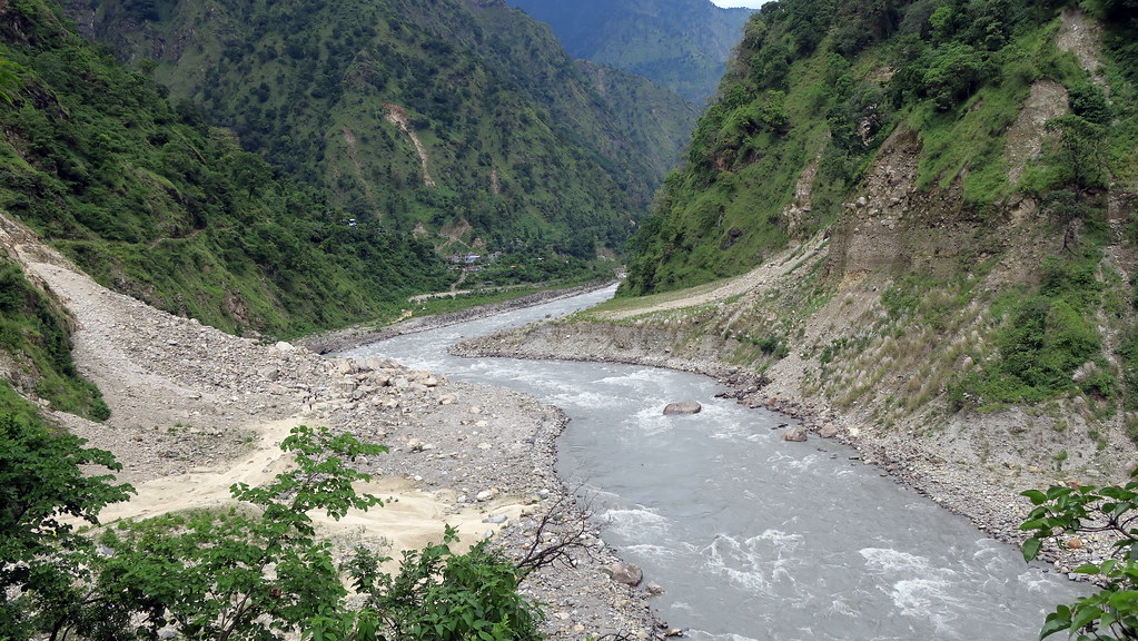
The lower section of the Manaslu Circuit follows the Budhi Gandaki River through narrow valleys, small settlements and forested hillsides. The trail passes through a mixture of stone steps, suspension bridges, rocky paths and sections close to the river.
One thing that stands out about this part of the route is the constant movement of the landscape. Sometimes the path runs close to the water, while elsewhere it climbs high above the river before descending towards another settlement.
The river is often a familiar sound throughout the day. In some places, the valley feels narrow, with steep hills rising on both sides. At other points, the trail opens enough to reveal terraced fields and small villages.
The lower villages also provide an opportunity to understand daily life in the region. People use the same trails for walking between settlements, carrying supplies and travelling to nearby fields. These are working mountain communities rather than places built only for visitors.
I would take this section at a steady pace rather than trying to cover too much ground early in the trek. The first few days are important for building a comfortable walking rhythm before reaching the higher elevations.
Experiencing the Villages Along the Trail
One of the reasons I would choose the Manaslu Circuit over a trek focused mainly on viewpoints is the opportunity to spend time in its villages.
Settlements such as Jagat, Deng, Namrung, Lho and Samagaun each sit within a different part of the route. As the trail climbs, the architecture, surrounding vegetation and mountain views gradually change.
In the lower settlements, the landscape remains relatively green. Higher up, traditional stone houses, prayer flags, mani walls and Buddhist monasteries become more noticeable.
The villages around the upper Budhi Gandaki Valley also reflect the cultural connections between Nepal and Tibet. Local customs, architecture and Buddhist traditions are an important part of the experience.
Rather than rushing through every settlement, I would leave time to walk around after arriving at the lodge. A short walk through the village can reveal details that are easy to miss while concentrating on the trail, such as prayer wheels, small shrines, fields and the way houses are arranged along the hillside.
I would also approach conversations with local people respectfully and ask permission before taking photographs, particularly inside homes or monasteries.
Staying in Local Teahouses
Accommodation on the Manaslu Circuit is generally based around local teahouses and mountain lodges. These provide a practical place to sleep, eat and rest between walking days.
I would not expect luxury accommodation throughout the route. Rooms are usually simple, and facilities become more basic in remote settlements. The exact comfort level depends on the village and the individual lodge.
A typical evening might involve reaching the lodge in the afternoon, ordering a hot meal, charging a phone if electricity is available and preparing for the following day's walk.
As the elevation increases, nights become colder. A sleeping bag suitable for the season is useful, even when blankets are provided.
The dining room is often the main shared space in a teahouse. Trekkers can eat, talk about the trail and check the weather before going to bed. For me, that would be an important part of the journey, because trekking is not only about the hours spent walking outside.
Food on the Manaslu Circuit
Food is another practical part of the trekking experience. Dal bhat, noodles, fried rice, soups, potatoes and other simple meals are commonly available along established sections of the route, although menus vary between lodges.
I would generally choose filling meals that provide enough energy for the following day. Dal bhat is particularly practical because it includes rice, lentils and accompanying vegetables, with refills sometimes available depending on the lodge.
Breakfast might include porridge, eggs, Tibetan bread or other items offered on the menu. Hot tea is also a regular part of mountain life, especially on cold mornings.
Food choices can become more limited in the higher villages because supplies must travel farther to reach them. Prices may also increase with elevation.
For that reason, I would carry a few snacks for longer walking days rather than assuming I could buy something at every point along the trail.
Reaching Namrung and Lho
As the trail climbs towards Namrung and Lho, the surroundings begin to feel more alpine. The route continues through mountain settlements, but the views become increasingly dominated by larger peaks and the upper valley.
Lho is particularly notable for its monastery and views towards Mount Manaslu when the weather is clear. I would try to spend some time looking around the village instead of arriving, eating and immediately going to bed.
Mountain weather can change quickly, so a clear view is never guaranteed. Clouds may cover the peaks even when the morning begins with good visibility.
That is one reason I would avoid planning the trek around photographs alone. The experience also comes from walking between villages, noticing changes in the terrain and adapting to the conditions.
Spending Time in Samagaun
Samagaun is one of the important settlements on the Manaslu Circuit. Its location makes it a useful place to rest and acclimatize before continuing towards the higher villages.
At this elevation, walking starts to feel different from the lower sections. The air is thinner, and even a short uphill climb may require more frequent breaks.
I would plan an acclimatization day around Samagaun rather than treating it as an unnecessary delay. Spending an extra day at the right point in the itinerary allows time to rest and explore nearby areas without moving to a higher sleeping elevation immediately.
Possible activities include walking around the village, visiting local cultural sites or taking an acclimatization hike when conditions and fitness allow.
The key is not to turn the rest day into another exhausting trekking day. I would walk at a comfortable pace, drink enough fluids and pay attention to how my body responds to the altitude.
The Changing Landscape Above Samagaun
Beyond Samagaun, the route becomes more exposed and the surrounding vegetation gradually thins. The landscape begins to feel more open, with rocky slopes, broad mountain views and fewer signs of the greener environment found lower down.
The trail towards Samdo leads through terrain where the effects of altitude become increasingly important. Walking slowly becomes more valuable than maintaining the pace used during the first few days.
Samdo is another useful settlement before the approach to Larkya La Pass. I would use the time here to check the weather forecast with my guide, organize warm clothing and confirm the plan for the next stages.
At this point, I would also pay closer attention to eating regularly and staying warm. Cold temperatures, wind and reduced appetite can make it harder to maintain energy at higher elevations.
Approaching Dharamsala and Larkya La Pass
The approach to Larkya La Pass is one of the main challenges of the Manaslu Circuit. Depending on the itinerary and current conditions, trekkers generally spend a night in the Dharamsala area before attempting the pass.
The accommodation here is basic, and the environment is considerably more exposed than in the lower villages. I would prepare for a cold night and an early start.
Crossing the pass is not simply a matter of walking uphill. The elevation, weather, trail surface and length of the day all influence how difficult it feels.
I would keep my warm layers, gloves, hat, water and snacks accessible rather than packing everything away. Starting early also means being prepared for cold conditions before the sun reaches the trail.
The final approach can feel slow because the terrain is steep in places and the altitude makes sustained effort harder. I would focus on short, manageable steps and follow the guide's instructions.
If the weather became unsafe, I would not treat reaching the pass as more important than safety. A trekking plan should allow for changing conditions rather than assuming that every crossing will go ahead as scheduled.
Crossing Larkya La Pass
Larkya La Pass, at approximately 5,106 metres, is the highest point of the standard Manaslu Circuit route.
The landscape around the pass is markedly different from the lower Budhi Gandaki Valley. Trees are largely absent, the terrain is rocky and barren, and snow or ice may affect the trail depending on the season.
Reaching the top would be a major moment in the journey. After several days of walking through villages and gradually gaining elevation, the pass represents the point where the route crosses from one side of the mountain landscape to the other.
I would spend only as much time at the top as conditions comfortably allowed. Wind and cold can be significant at this elevation, and the descent still lies ahead.
The views can include surrounding Himalayan peaks, although visibility depends on the weather. I would not assume the pass would be clear simply because the forecast looked favourable earlier in the day.
The descent towards Bimthang is also an important part of the crossing. After the effort of reaching the pass, tired legs and uneven ground require continued attention.
Descending Towards Bimthang
After crossing Larkya La, the route descends towards Bimthang. The change in terrain provides a different perspective on the mountains and the valley below.
The descent can be physically demanding, especially after a long day at altitude. Even when walking downhill, the knees and ankles take considerable strain on rocky or uneven sections.
I would avoid rushing simply because the highest point was behind me. Maintaining a controlled pace is important, and trekking poles can be useful on long descents.
Bimthang provides a place to rest after the pass crossing. Depending on the conditions and itinerary, reaching the settlement can feel like a significant transition from the exposed high-altitude landscape to the lower sections of the route.
I would make sure to eat, drink and recover properly before continuing towards the end of the circuit.
Returning Through the Lower Valleys
After Bimthang, the trail continues downhill through changing vegetation and mountain settlements towards the Dharapani area. The environment gradually becomes greener as the elevation decreases.
The final walking days can feel different from the approach to Larkya La. The biggest altitude challenge may be behind you, but the accumulated fatigue from many days of walking remains.
Depending on road conditions and the agreed itinerary, the trek typically finishes around Dharapani, from where onward transport can be arranged.
I would confirm the transport plan in advance rather than assume that a vehicle would be waiting at a particular time. Road conditions and travel arrangements can change, particularly in remote mountain areas.
Looking back, the route is best understood as a gradual journey through different environments: river valleys, traditional villages, Buddhist cultural landscapes, high mountain settlements and the barren terrain around Larkya La.
What I Would Keep in Mind Before Trekking Manaslu
The Manaslu Circuit is not a trek I would plan only around the number of days needed to complete it. The route requires preparation for altitude, changing weather and long walking days.
These are the main things I would consider before setting out:
-
Walking pace: Start slowly and avoid exhausting yourself during the first few days.
-
Acclimatization: Allow time to adjust to the elevation before attempting Larkya La.
-
Clothing: Carry layers suitable for both warmer lower valleys and cold, exposed mountain conditions.
-
Cash: Carry enough Nepali rupees because reliable banking services are not available throughout the route.
-
Navigation: Use a suitable map and follow your guide, especially at confusing junctions or in poor visibility.
-
Permits and guide: Arrange the required permits and a registered guide through an authorized trekking agency. Check the latest rules before departure.
-
Weather flexibility: Allow for delays if conditions make the pass unsafe.
-
Travel insurance: Choose insurance that explicitly covers trekking at the intended altitude and emergency evacuation where needed.
I would also avoid comparing every day with a fixed schedule. Walking speed, weather, trail conditions and individual fitness can all change how long it takes to reach the next village.
Is the Manaslu Circuit Trek Worth Doing?
For trekkers who want to experience traditional mountain settlements, a quieter Himalayan route and the physical challenge of crossing a high pass, the Manaslu Circuit is worth considering.
Its appeal is not limited to Mount Manaslu or Larkya La. The lower Budhi Gandaki Valley, the villages around Namrung and Samagaun, local teahouse life and the gradual change in landscape all contribute to the journey.
It is also important to understand what the trek involves. Accommodation is simple in places, the roads to and from the trail can be rough, and the high-pass crossing requires preparation. It is not the right route for someone who wants a comfortable holiday with minimal walking.
For me, the strongest reason to choose this route would be the combination of village life, cultural encounters and the changing Himalayan landscape. Rather than rushing towards the highest point, I would take the time to experience the journey between the settlements.